


WaterCube offers an array of services to meet your instrumentation, data collection and processing needs.
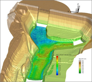
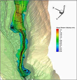
WaterCube uses field data to create a database of the land forms and hydraulic conditions of a body of water. The core of this database is a 3D water velocity grid overlaid onto a detailed elevation grid of the land. This database is then used to create plots, maps, images and digital data that allow the user to truly see and understand what is happening in and around the water.
Since WaterCube uses real world field data, the methods used and the care taken collecting the data will greatly impact the quality, value, and usefulness of the WaterCube results.
Traditionally, bodies of water were surveyed on a point-by-point basis. Data collection was laborious, and the results covered only a small fraction of the total area. Models and assumptions were required to try and fill in the many areas for which no data was available.
Two new technologies have greatly expanded the ability to collect hydraulic survey data.
For water, the Acoustic Doppler Current Profiler (ADCP) is an acoustic instrument that measures both the bathymetry (water depth) and a detailed 3D velocity profile over the full depth of the water.
Most importantly, ADCPs can be integrated with a GPS system allowing them to be operated from a moving vessel – continuously and quickly mapping conditions throughout a large study area.
WaterCube offers services to assess your study area, provide the gear and collect the data, certify and train your personnel for future data collection efforts and process your data to create a complete DEM in days.
Whether we collect the data for you or you provide it to us, we ensure quality processed results that will visualize your river like never before.