Visualize Your River, Like Never Before!
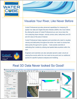
Cubeit Professional provides advanced capabilities for Analyzing 3D spatial river data and Digital Elevation Models (DEM’s) like never before. By utilizing the power of Cubeit Professional you can move down the river analyzing slope changes, velocity contour plots, bathymetry and 2D and 3D views of the area of interest.
Cubeit Professional helps engineers and scientists who need to visualize velocity and bathymetry throughout the entire river reach to access that data quickly through built in queries. It also assists scientists in calibrating their models by utilizing real spatial data anywhere within the river.
Engineers and scientists can also calculate dynamic water volume at varying flow events within the river reach at any point and run additional queries for specific hydraulic analyses and modeling.

Click the image below to download our Cubeit Professional data sheet in PDF format: